390 Codes Postaux à Uttarakhand
Afficher une liste de Codes Postaux pour Uttarakhand| Fuseau horaire | heure de l’Inde |
| Région | 53,695 km² |
| Population | 11.1 million (Plus de détails) |
| Densité de population | 207 / km² |
| Population masculine | 5 658 964 (51.0%) |
| Population féminine | 5 447 583 (49.0%) |
| Age moyen | 24.0 |
| Codes Postaux | 244711, 244712, 244713 (387 plus) |
| Codes Téléphone | 1332, 1334, 1348 (28 plus) |
| Commerces à Uttarakhand | 556,029 |
| Villes | 54 |
Plages de Code Postal
| Codes Postaux▲ | Ville↕ | Nombre de codes postaux↕ |
|---|---|---|
| 246123 - 246125, 246146 - 246148, 246163 - 246167 | Pauri | 16 |
| 246124 - 246127 | Kotdwāra | 7 |
| 246128 - 246131 | Lansdowne | 11 |
| 246424 - 246426, 246444 - 246474, 246487 - 246489 | District de Chamoli | 17 |
| 248001 - 248252 | Dehradun | 38 |
| 249127 - 249132 | Tehri | 7 |
| 249185 - 249196 | Uttarkāshi | 10 |
| 249401 - 249411 | Haridwar | 10 |
| 262501 - 262521, 262540 - 262543, 262561 - 262574 | Pithoragarh | 18 |
| 263001 - 263144, 263155 - 263164 | Nainital | 24 |
| 263622 - 263629, 263636 - 263638, 263681 - 263689 | Almora | 22 |
| 263628 - 263635, 263640 - 263642 | Bageshwar | 14 |
| 263645 - 263651 | Rānikhet | 6 |
Carte interactive
390 Codes Postaux à Uttarakhand
| Code Postal▲ | Ville↕ | Population↕ | Région |
|---|---|---|---|
| 244711 | Rānikhet | — | — |
| 244712 | — | 103,637 | 215.5 km² |
| 244713 | Kashipur | 316,235 | 251.2 km² |
| 244714 | Kashipur | — | — |
| 244715 | Nainital | 156,181 | 783.7 km² |
| 244716 | — | 2,893 | 23 km² |
| 244717 | — | 1,969 | 1.878 km² |
| 246001 | Pauri | 49,556 | 88.2 km² |
| 246113 | Pauri | 3,721 | 43.1 km² |
| 246121 | Kotdwāra | 6,643 | 203.9 km² |
| 246122 | — | — | — |
| 246123 | Pauri | 48,406 | 192 km² |
| 246124 | Kotdwāra | — | 15.3 km² |
| 246125 | Pauri | 9,953 | 21.2 km² |
| 246127 | Kotdwāra | 3,152 | 119.6 km² |
| 246128 | Lansdowne | 5,779 | 96.9 km² |
| 246129 | Lansdowne | 1,111 | 53.6 km² |
| 246130 | — | 19,064 | 165.4 km² |
| 246131 | Lansdowne | 757 | 30 km² |
| 246132 | — | — | — |
| 246135 | — | — | — |
| 246141 | Rudraprayāg | 5,033 | 240.1 km² |
| 246142 | Kālāgarh Project Colony | 13,132 | 414.1 km² |
| 246144 | Kotdwāra | 16,356 | 318.1 km² |
| 246146 | Pauri | 6,260 | 68.6 km² |
Showing 1-25 of 390
…
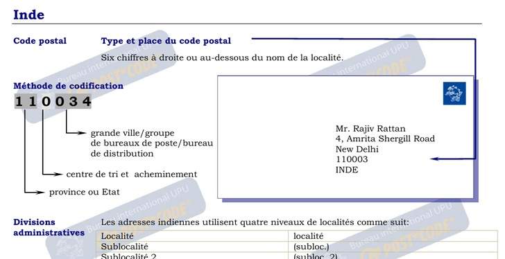
Exemple d'adresse
Informations démographiques de Uttarakhand
| Population | 11.1 million |
| Densité de population | 207 / km² |
| Population masculine | 5 658 964 (51.0%) |
| Population féminine | 5 447 583 (49.0%) |
| Age moyen | 24.0 |
| Age masculin moyen | 23.3 |
| Age féminin moyen | 24.7 |
| Commerces à Uttarakhand | 556 029 |
| Population ( 1975) | 5 281 162 |
| Population ( 2000) | 8 801 746 |
| Évolution de la population de 1975 à 2015 | +110.3% |
| Évolution de la population de 2000 à 2015 | +26.2% |
Villes les plus peuplées en/de Uttarakhand
Uttarakhand
'Uttarakhand (hindi : उत्तराखण्ड Uttarakhaṇḍ), précédemment l'Uttaranchal, est un État indien depuis le 9 novembre 2000. Auparavant, l'Uttarakhand faisait partie de l'Uttar Pradesh. 'Uttarakhand est bordé par le Tibet (contrôlé par la Chine) au nord-est, le N..
Page Wikipédia de Uttarakhand